Mesh Network Project
This page describes how DeHR will use the Holochain Web3 platform and Competitive Edge technology’s HR application framework to build a peer-to-peer network in Australia and demonstrate the DeHR consortium’s Governance function. The page will step through a process that could form the structure of a Roadmap as companies transition to a new digital computing environment and satellite enabled space precinct:
- Identifying companies that are eligible to join the network.
- The process of collecting data about those companies that will be necessary to know who they are, where they are including geolocation details, who are their management team or decision makers, the nature of their business, how many employees they have and establish whether they are suitable to host the network infrastructure or whether they wish to use a proxy IT organisation.
- Identify hosting revenue opportunities based on microgrid geolocation details and current internet delivery options.
- Introduce the emerging satellite wireless internet network, how it lays a platform for Edge Computing that enables AI, IoT, remote sensors, data and solar power delivery to anywhere on earth.
Companies eligible to join the DeHR Network
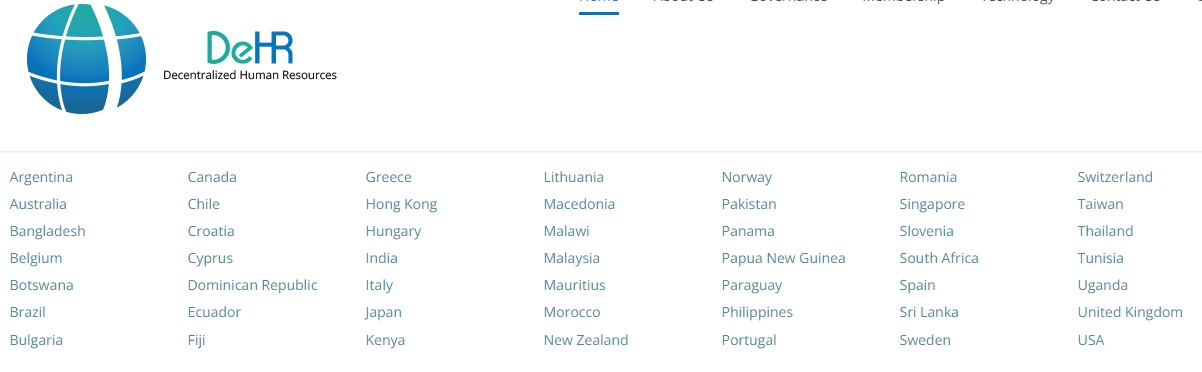
DeHR is setting up a Governance Subcommittee to help member HR associations, or nominated hosting agents, develop a set of rules relevant to their local government regulations. A list of invited countries (shown below) appears on the front page of this website, along with links to the relevant HR association, and it the Membership space.
The Australian environment is the use case selected for this stage of network development. A list of preapproved companies appear on this site, shown in the diagram below, along with an example of eligibility rules for Australia.

Preapproval List & Governance Rule


Network Participant & Data Collection
An example of CET’s CRM database, with 4,800 potential participants employing 4 million staff, appears below showing data stored for companies to know who they are, who are their management team or decision makers, the nature of their business, and how many employees they have: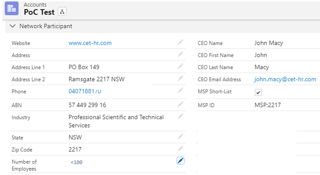
NOTE: The database is pre-COVID and does not include government departments or companies employing less than 100 staff.
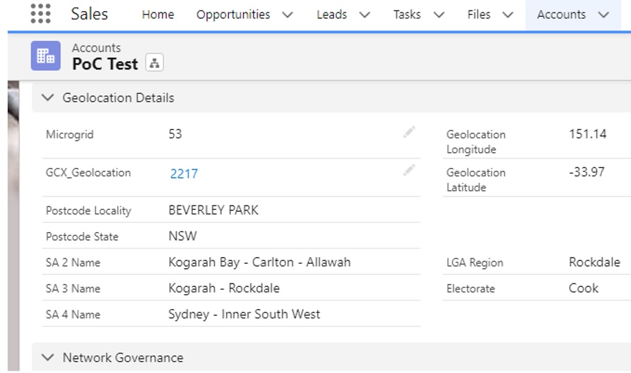
Geolocation details (zip code with longitude and latitude details) and what Microgrid the company has been assigned to:
Establish and record whether they are suitable to host the network infrastructure or whether they wish to use a proxy IT organisation: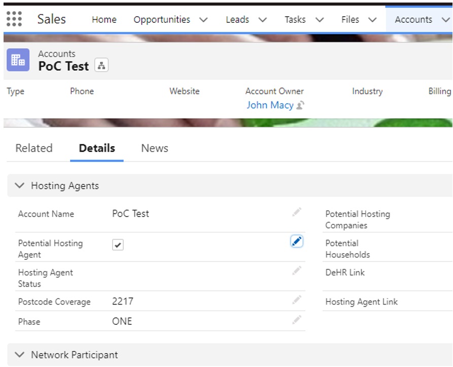
Microgrid Positioning & Revenue Opportunities
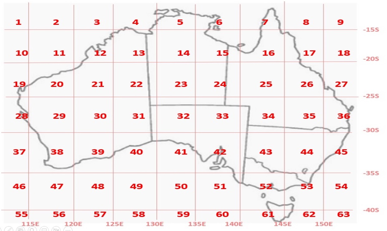
For a network to be manageable the country needs to be divided into geographic regions based on longitude and latitude coordinates for the purposes of constructing Microgrid centres. The diagram below illustrates how Australia is divided in the CET database:
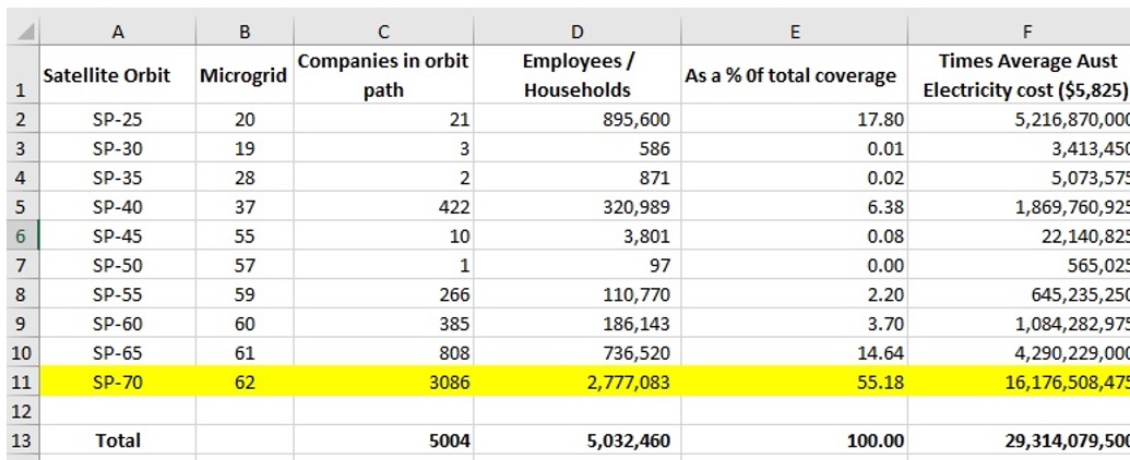
Once company geolocation details are know it is possible to plot their position on a Microgrid map and determine company and employee numbers in those Microgrids, shown below:
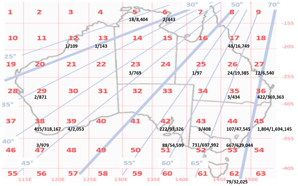
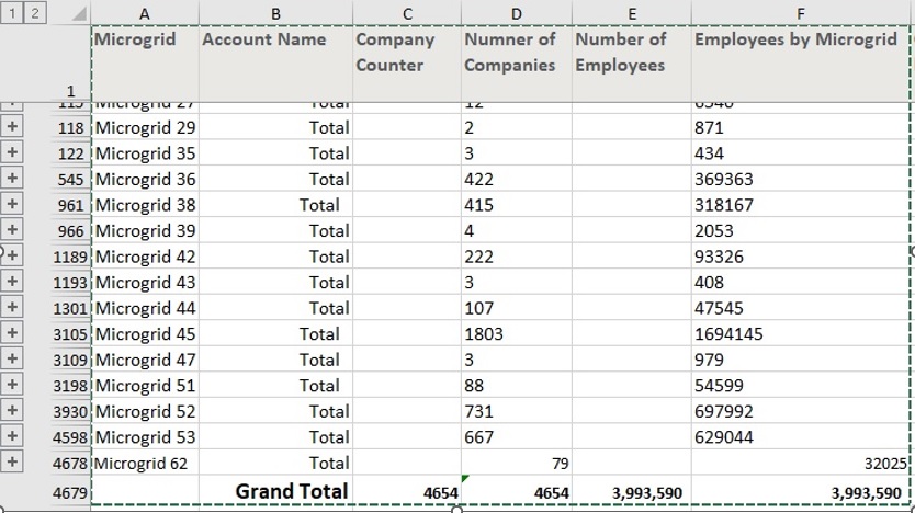
The total number of companies in the test network is 4,654 employing 3,993,590 staff, described in the spreadsheet below.
More details of the Microgrids in Australia can be found at Australian Microgrid Network on this site, including postcodes, suburbs covered by each postcode and potential hosts identified. Links to each state are shown below:
Australian Capital Territory | New South Wales | Northern Territory | Queensland | South Australia | Tasmania | Victoria | Western Australia
Satellite Wireless Data and Power Network – PoC
Everything described above has been based on existing infrastructure capability. If the DeHR network can be set up in Australia it will be able to support a new initiative for delivering data and power to decentralised communities across the country. The potential impact on electricity costs is a staggering $0.3 trillion AUD dollars over 10 years (the average life span of a satellite).
Satellite Orbit Paths
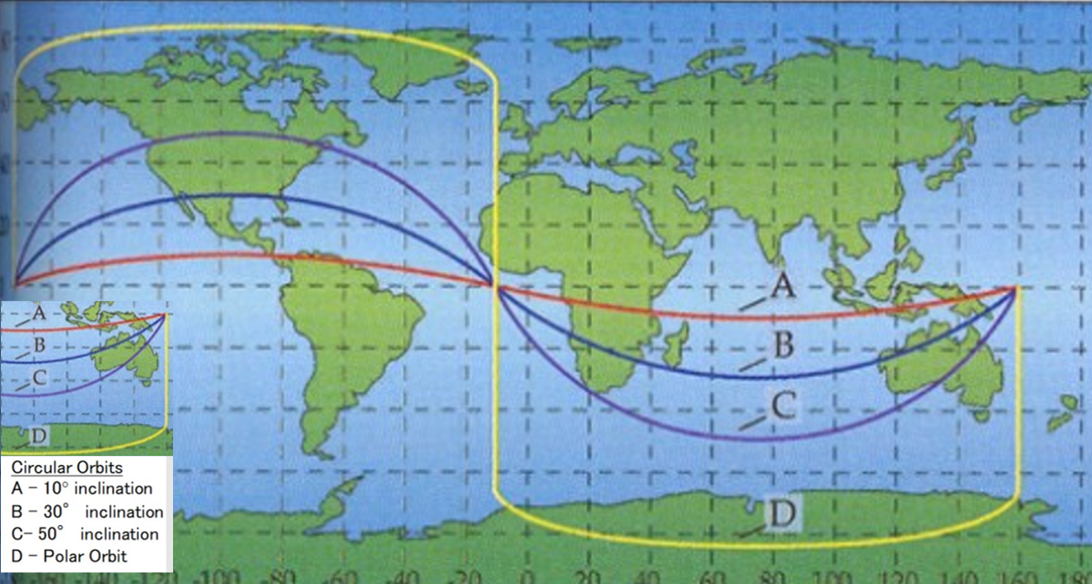
The initiative focuses on satellite constellation orbit paths in Low Earth Orbit (LEO). Orbit paths are calculated in relation to the equator orbit path of zero. The diagram below illustrates how the orbit INCLINATION path is calculated:
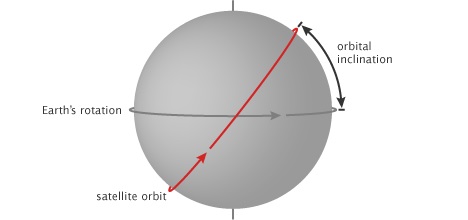
“Inclination is the angle of the orbit in relation to Earth’s equator. A satellite that orbits directly above the equator has zero inclination. If a satellite orbits from the north pole (geographic, not magnetic) to the south pole, its inclination is 90 degrees”. Courtesy of NASA
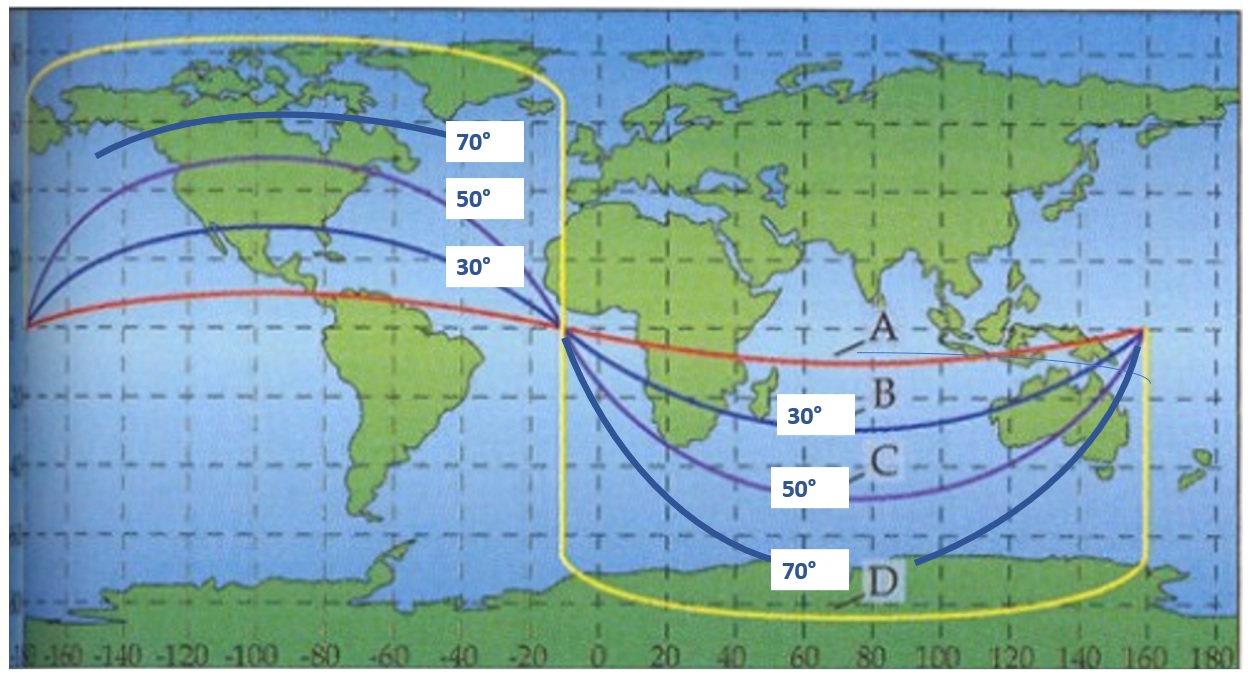
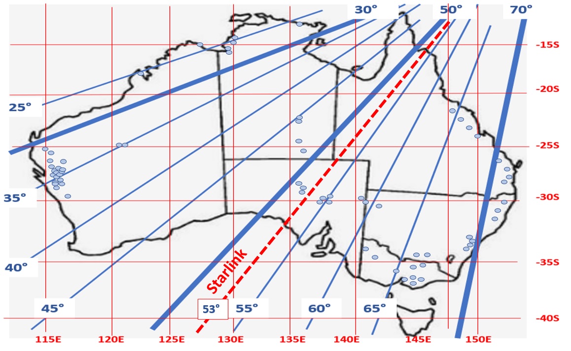
Starlink Satellites in LEO Orbit
The NASA diagram below illustrates the current Starlink orbit paths in LEO.
A current Starlink orbit path is 53 degrees, shown in more detail below:

The current 53 degree satellite constellations track over heavily populated areas in North America, but only passes over sparsely populated areas in Australia. There is an application to allow orbiting satellites along a 72 degree orbit path that will take the Starlink constellations over the more heavily populated areas along the east coast, shown in the diagram below.
The planned Starlink constellation would pass over some of the more lucrative Microgrids and potentially have access to a large slice of electricity revenue along the path.
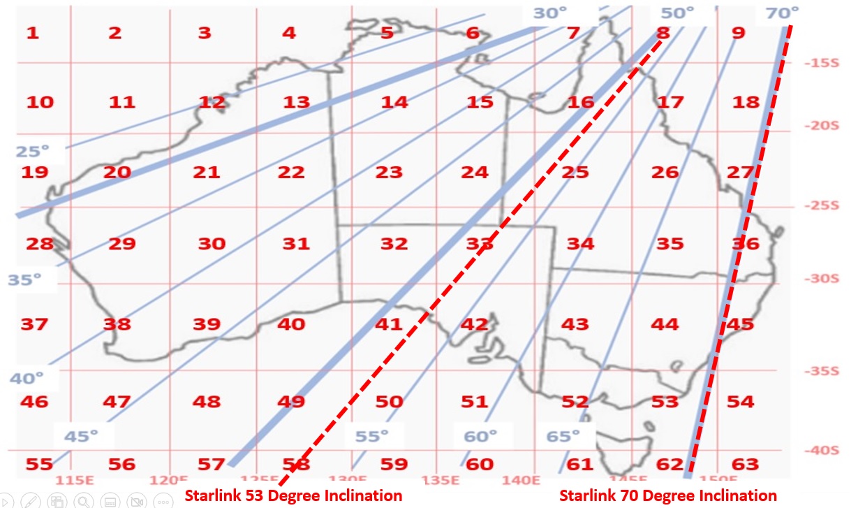
In addition to the Starlink orbit, the diagram above shows the other orbit paths that would pass over Microgrids in Australia.
For each satellite orbit it is possible to calculate the potential savings and electricity costs impacted
Electricity Cost Impact
If the 3,993,590 employees and potential households average electricity cost was $5,825 the potential impact is $23,262,661,750 per year, or $23.3 billion.
If the average satellite life span was 10 years (estimates range from 5 to 15 years) the electricity costs could be $230.3 billion or $0.23 trillion dollars. A lot of satellites could be launched for that amount of money.
If satellite orbits (see the list in the diagram below) could be allocated to companies there would possibly be an overlap of satellite orbits: That is, more than one satellite constellation could pass through the same microgrid. However, the business model would still be very attractive.
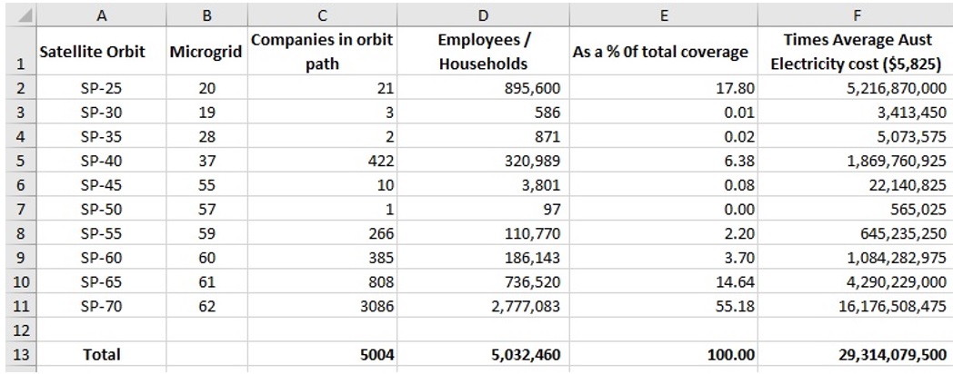
Note the potential of the SP-70 (70 degree inclination orbit requested by Starlink) highlighted below:
The Massive Benefits Possible from Wireless Gravity + Solar Power Availability
If the cost of wires and poles transmission amounts to approximately 60% of a household bill a potential reduction in bills could amount to $14.0 billion per annum, if the gravity and solar power satellite wireless beaming was successful
Even if the 40% could be impacted by better microgrid management of renewable resource options (solar panels, wind, etc.) through workforce data to estimate load usage (eg. Electric vehicle ownership, swimming pool, etc) the $9.3 billion could be impacted.
The Promise of Gravity Power
To illustrate the viability of gravity power, and the concept of beaming kinetic energy produced by using old mine shafts to generate power and transmit to overhead satellites, the map below shows the network population masses in relation to satellite orbits.
If the same map was used to illustrate the location of inactive mineshafts in Australia, shown below, it would indicate an abundance of energy sources.
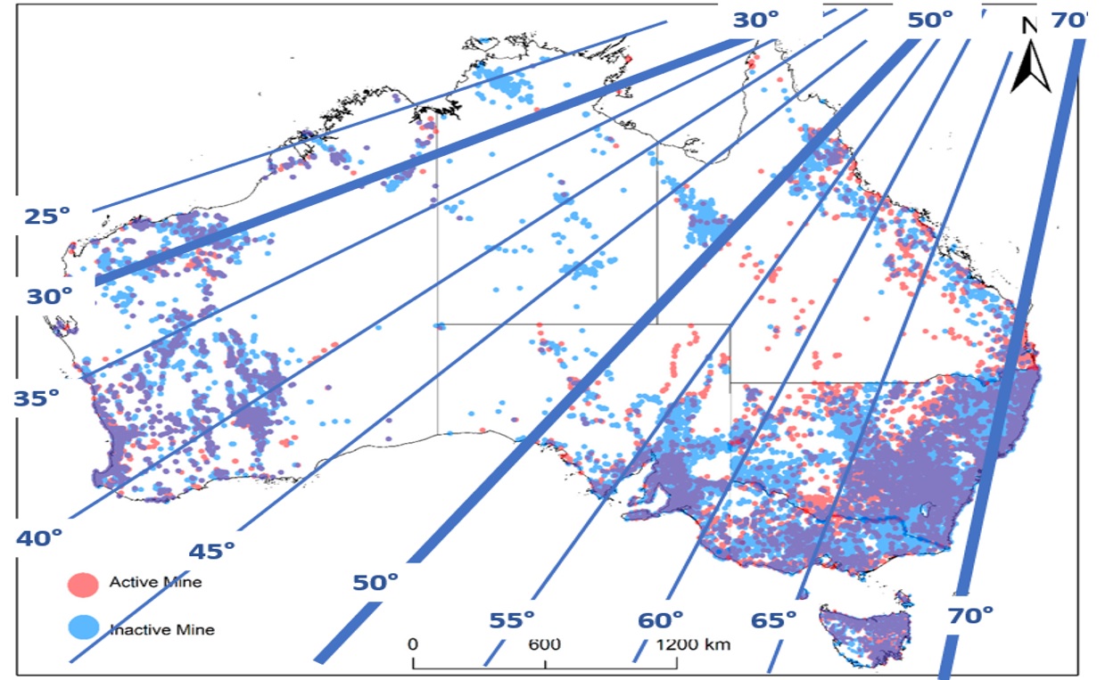
It should be remembered that the calculations earlier only related to Australia and satellite constellations travel across many countries and every country has inactive mine shafts.
If Gravity Power can be transmitted using laser or microwave beams and bounced off satellites, after magnification, back to rectennas on earth can be proven, it opens up a cheap 24 hour source of renewable energy. The issue is whether the amount of electricity can be scaled up to household commercial levels.
What Next
If gravity + solar power could be scaled up to commercial expectations and proven, it would also open the door to commercially realistic orbiting 3D organ printing factories with zero gravity. Compared to the International Space Station (ISS), orbiting in LEO, an orbiting organ printing factory would require 80% less infrastructure to draw power. Much of the ISS structure is a massive array of solar panels and battery storage to compensate for loss of sunlight.
Much depends on gravity power’s ability to enable wireless power transmission and 24 hour electricity supply.
There will be many more use cases emerge as Edge Computing introduces new products and processes to industry based on earth and introduces new challenges to HR to manage the industrial precinct.